Severe Weather Targets Kansas Tonight While Nebraska Faces Flooding Threat
A powerful storm system is actively tracking across the central U.S. tonight, bringing a significant severe weather threat to Kansas while southeastern Nebraska braces for heavy rainfall and potential flooding into early Monday.
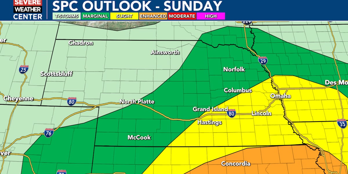
The National Weather Service has issued a Severe Thunderstorm Watch until 4 AM for northern Kansas, where storms are expected to unleash damaging large hail, gusty winds, and torrential downpours. This wave of severe weather is primarily concentrated south of Nebraska, shifting the risk away from that state but not eliminating the threat completely.
Across Nebraska, showers and isolated thunderstorms will continue moving in through the overnight hours. While some storms may still produce strong gusts or hail, the risk of severe activity has diminished as a warm front fueling the thunderstorm development remains positioned further south, keeping most intense storms in Kansas.
Flood concerns are mounting in southeastern Nebraska, where a Flood Watch is in effect from 7 PM Sunday through 1 PM Monday. Slow-moving storms could cause heavy rainfall capable of triggering flash flooding, especially in urban areas and low-lying zones prone to water accumulation. Residents in affected areas should stay alert for rapidly changing conditions and be prepared to take safety measures as needed.
Monday’s Forecast: Windy, Cool, and Cloudy
Storms will gradually move out by early Monday evening, but the weather will remain unsettled. Northwest winds will strengthen, gusting as high as 40 mph Monday afternoon, ensuring temperatures stay below seasonal averages. Any warmth will be fleeting, giving way to a cool, windy afternoon across Nebraska and neighboring states.
Tuesday will bring mostly cloudy skies with highs only reaching the upper 40s to upper 50s. While a small chance for light rain exists, no significant precipitation is expected. Conditions are forecast to improve slowly as the week progresses.
Midweek Outlook and Freeze Risk
By Wednesday, temperatures will climb into the 60s, accompanied by scattered showers and a chance of thunderstorms. Thursday will see similar conditions with highs in the low 60s and minimal rain chances.
Attention is turning to the potential for frost and freeze conditions Tuesday night into Wednesday morning in central and northern Nebraska. Gardeners and those with outdoor plants are advised to take precautions to protect tender vegetation from the cold.
End of Week and Weekend Outlook
Friday will warm to the upper 60s in Lincoln, Nebraska, and the temperature rebound continues over the weekend with highs back in the 70s on Saturday and Sunday. Dry, pleasant weather is expected, offering a welcome break after a disruptive start to the week.
“Storms could produce heavy rain in some areas, which is why a Flood Watch is in effect for southeastern Nebraska,” said a National Weather Service spokesperson.
Residents across Kansas and Nebraska should stay updated with the latest forecasts and watches through trusted sources like 10/11 NOW and the National Weather Service. Given the fast-changing weather, preparedness for strong winds, hail, flooding, and cold snaps remains critical as these systems continue to evolve.