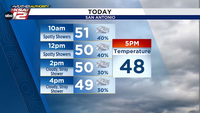
URGENT UPDATE: A cold front is sweeping through the area this morning, bringing a significant drop in temperatures and persistent damp conditions. As temperatures plummet from the mid-50s to the upper-40s by this evening, residents should prepare for fog, drizzle, and breezy conditions.
Beginning early today, expect light showers to affect the morning commute, making travel potentially hazardous. Meteorologists from KSAT Weather Authority confirm that rain will be light but could create slippery roads. If you’re heading out, take precautions to stay safe on the roads during this damp weather.
Friday will see temperatures struggling to reach 50°F in the afternoon, with skies expected to clear by Friday evening. The cool, cloudy weather is expected to linger, but the weekend forecast brings a refreshing change.
Get ready for a beautiful Saturday and Sunday! Sunshine returns, with temperatures soaring to a pleasant near 70°F on Saturday. A slight breeze may accompany Sunday, but no rain is in sight as a weak front passes through.
For those planning outdoor activities this weekend, it’s a perfect opportunity to enjoy the sunshine after today’s chilly conditions.
Stay informed with the latest updates by downloading the KSAT Weather Authority App for real-time forecasts and watch live Doppler Radar.
Don’t miss out on this weekend’s pleasant weather while staying updated on the immediate changes occurring today!