Recent advancements in soil monitoring have been made through the development of a dynamic parameter optimization algorithm, which enhances the detection of soil freeze-thaw (FT) transitions from space. This research, conducted by a collaboration between Fudan University, the University of Twente, and Chengdu University of Information Technology, was published on September 10, 2025, in the Journal of Remote Sensing.
The study addresses significant challenges in capturing FT transitions, which have direct implications for weather patterns and hydrological cycles. Traditional models often overlook the rapid changes in soil temperature and surface variability, leading to inaccuracies in large-scale climate models. The research team has focused on leveraging L-band microwave remote sensing, known for its sensitivity to soil dielectric properties and capability to penetrate snow and vegetation.
Existing algorithms based on the Soil Moisture Active Passive (SMAP) satellite data utilize fixed parameters across diverse climates and land covers, resulting in limited effectiveness. To tackle this issue, the researchers developed a new framework that dynamically adjusts parameters to regional characteristics, enhancing the precision of soil FT mapping.
The improved algorithm is an upgrade to the Diurnal Amplitude Variation-based Freeze-Thaw (DAV-FT) method, introducing three key parameters—α, β, and γ. These parameters represent the detection period, variance window, and threshold sensitivity. By employing a process similar to maximum likelihood estimation, the algorithm optimizes these parameters to maximize overall classification accuracy across different regions.
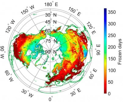
The results of this study demonstrate a significant improvement in performance. The areas achieving an overall accuracy (OA) greater than 0.7 increased from 54.43% to 89.36%, with the most notable results observed in the Qinghai–Tibet Plateau, southwestern Eurasia, and southern North America. The new model also showed high consistency with the ERA5-Land dataset at 81.28% and with SMAP-FT at 79.54%.
Validation was conducted using data from 828 in situ soil temperature stations, confirming the algorithm’s enhanced accuracy and stability. The median accuracy achieved was 0.92, outperforming both fixed-parameter models and existing SMAP products.
Dr. Shaoning Lv, the corresponding author of the study, emphasized the significance of this advancement. He stated, “The dynamic parameter optimization significantly enhances our ability to capture subtle soil freeze-thaw transitions that vary across regions and seasons. By reflecting diurnal surface changes in real time, our method not only refines the retrieval accuracy of L-band data but also provides a more physically consistent understanding of land-atmosphere interactions.”
The implications of this enhanced DAV-FT algorithm are substantial. It offers a more robust framework for continuous monitoring of soil freeze-thaw cycles across varied terrains. This capability is invaluable for climate modeling, agricultural management, and hydrological forecasting. The algorithm’s adaptability to account for diurnal temperature cycles and regional differences makes it particularly beneficial for high-latitude and mountainous areas where existing methods have limitations.
By improving the accuracy of soil state detection from space, this research strengthens the foundation for assessing critical factors such as permafrost dynamics, water availability, and land-atmosphere energy exchanges. These elements are vital for predicting the impacts of climate change and refining global land-surface models.
This study was funded by the National Key R&D Program of China, the Key Research and Development and Achievement Transformation Program of Inner Mongolia Autonomous Region, the Yan Liyuan–ENSKY Foundation Project of Zhuhai Fudan Innovation Research Institute, and the National Natural Science Foundation of China.
The findings underscore the importance of ongoing research in remote sensing and its role in understanding complex environmental processes, paving the way for more effective climate monitoring on a global scale.

