Heavy Rainstorm Delivers Major Soaking Across South Carolina Upstate Corridor
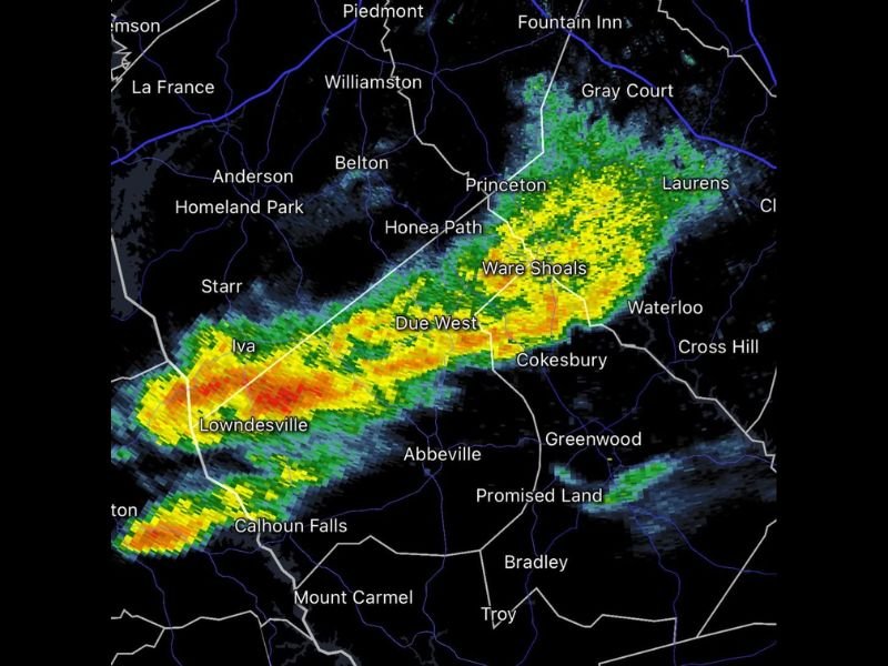
A powerful band of heavy rain swept through a key corridor of South Carolina’s Upstate region, delivering critical drought relief across Abbeville, Greenwood, and Laurens counties today. Radar confirmed an intense, fast-moving precipitation band stretching from Iva and Lowndesville northeast through Ware Shoals, Due West, and Laurens, dumping significant rainfall after weeks of dry conditions.
This organized rain band, marked by deep red and orange radar cores, produced heavy rain rates in a narrow but intense swath, particularly across communities such as Cokesbury, Promised Land, Waterloo, and Cross Hill. Observers noted some of the highest rainfall totals recorded in recent weeks, with persistent pounding rain creating concerns about localized flooding in low-lying areas.
Focused Intensity Hits Abbeville and Greenwood Counties
The heart of the storm’s intensity was observed moving directly through Abbeville and Greenwood counties, where radar imagery displayed some of the most severe rain returns. This corridor from Iva to Due West, extending toward Gray Court, saw exceptionally heavy rain rates capable of quickly saturating soil and overwhelming drainage systems.
Communities in these counties, long parched during a recent dry spell, finally experienced much-needed and beneficial soaking. The persistent rainfall is providing a vital replenishment to local water tables and reservoirs, helping to ease the drought conditions that have impacted agriculture and everyday life.
Broader Coverage Brings Widespread Relief Across the Upstate
While the most intense precipitation tracked along the Abbeville-Greenwood axis, lighter but steady rain extended further across the South Carolina Upstate. Areas including Anderson, Belton, Princeton, Williamston, Honea Path, and Fountain Inn also saw measurable rainfall, ensuring a broad swath of drought-affected communities caught a break.
The widespread rainfall has immediate benefits for farms, gardens, and water supplies, many of which were struggling after weeks without significant rain. Agriculture experts expect this moisture boost to improve conditions for crops and livestock throughout the region.
Heavy Rainfall Marks a Turning Point in Seasonally Dry Period
Residents across Calhoun Falls, Ware Shoals, and Laurens County reported the heaviest rainfall they’ve seen in weeks as the storm passed. The event stands out as a critical turning point amid a spring marked by drought concerns, helping to stabilize soil moisture and reduce fire risk.
Local officials are monitoring for flood threats, particularly where drainage is poor or streams run high, but initial reports indicate primarily beneficial impacts so far. Emergency services remain on alert as the band continues to push northeast, and travel advisories are in effect for areas affected by steady rain and potential flooding.
Next Steps and What to Watch For
Meteorologists at nearby weather stations continue to track potential follow-up systems that could bring additional rain or storms. Residents are advised to stay updated via local weather channels and prepared for variable conditions as the broader weather pattern remains active.
This heavy rain event is a clear reminder of the changing weather dynamic across the Southeast and the ongoing need for preparedness and resilience in the face of drought and heavy rains alike.
“This rainfall event provides much-needed drought relief for our communities,” said a local official. “While we must remain watchful for flooding, the soaking is a blessing for our region’s farmers, water supplies, and ecosystems.”
For continuous updates on weather developments and impacts across the Southeast and beyond, stay with The NC Voice and trusted local sources.